 Order crests, pins and name tags online!
 Land Surveyor Challenge
in partnership with
Association of Canada Lands Surveyors (ACLS)
Goal:
Surveying is the technique, profession, and science that’s shaping our world- literally! This challenge will introduce girls to the science behind the technology and day–to-day experiences all around them. Upon completion of this challenge, girls will be better equipped to fulfill the GGC vision “a better world, by girls.”
Challenge Overview:
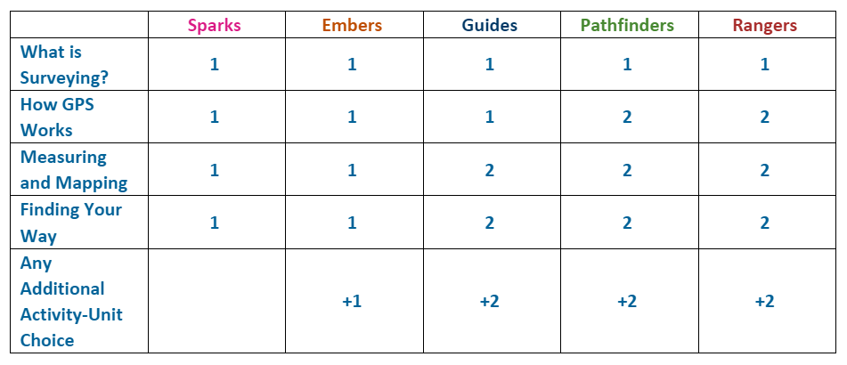
The Land Surveyor Challenge has four parts and can be adapted to suit all branches. The activities build STEM and outdoor skills that are central to the Guiding program.
Challenge Requirements:
This table shows the number of activities you need to complete to earn the challenge.
What is Surveying?
-
Discussion and dramatization
Surveying is technique where math meets geography. Surveyors measure and record features of a land area that are used to establish land maps and boundaries. These areas are usually on or near the Earth’s surface, although surveying is also how we explore the surface of Mars! Here is an overview of what a land surveyor does.
Surveying is part of an over-arching umbrella of science called “geomatics”. This is the discipline of gathering, storing, processing and delivering geographic or spatially-referenced information. Geomatics is used in solving land and boundary disputes, making online maps and looking at population patterns for shifts in culture, voting choices and even diseases.
In the aftermath of natural disasters, geomatics and global positioning systems (GPS) are used to pinpoint those in need of help, reconnect people with their friends and loved ones and make sure that everyone has access to nearby shelters. Before disasters strike, we can forewarn residents and make evacuation plans using geomatics to map out potential paths of flooding and storm movements.
Most girls are familiar with the idea of GPS so this can be a good jump-off point to engage them on why finding a specific point is important. How do your girls think GPS could be used? Here are some ideas to help you get started:
- Cartography (map-making)
- Cellular technology
- Clock synchronization
- Disaster relief (mapping diseases and outbreaks, predicting shifts in weather)
- Emergency services (ambulances finding the fastest route to their target)
- Tracking vessels at sea and in the air
- Tracking wildlife
- Measuring earthquakes
- Self-navigating robots
Once they’ve got a general idea, split the girls into groups. Each group chooses a specific activity that surveyors do (e.g. making sure each end of a tunnel is dug in the correct spot, measuring heights of tall things, finding lost monuments…etc.) and get a few minutes to put together a 1-minute skit showing why the activity is important.
How GPS works
GPS uses satellites to get a precise location. Each satellite in space has a footprint on Earth in which the GPS receiver (e.g. a smart phone) must be located. With just one satellite, the potential area or footprint is large. When you add another satellite, the overlapping area is a little smaller. With at least four satellites, there is only one position where all footprints overlap. This gives the precise location of the GPS receiver.
-
Table GPS
You will need a map to draw on and three circular objects (cup, plate, etc.) of varying sizes. Have one girl draw out a circle on the map. Notice how much area that covers? That represents the footprint of one satellite your GPS device is using. The GPS receiver could be anywhere in that circle. Now draw another circle that intersects. The overlapping area is now somewhat smaller but not really precise. Draw a final circle that intersects with the overlapping area. Now there is only one place where all three circles overlap and this would be the location of the GPS receiver. Try making more circles to get a more precise position!
-
Human GPS
This active demonstration involves seven volunteers and three different lengths of rope. One person is the “fixed point” where the GPS receiver is standing. Three others are satellites. Each satellite holds a different length of rope; this is the radius of their footprint. The three remaining volunteers each hold a loose end of rope, stand as far from the satellite as the rope allows and orbit the satellite to show the footprint circumferences.
-
Geocaching
Geocaching is a real-world, outdoor treasure hunt using GPS-enabled devices. As a unit, navigate to a specific set of GPS coordinates and then attempt to find the geocache (container) hidden at that location. Find more information here.
-
Scavenger Hunt
Do a scavenger hunt around your city, campground or other location. Find or create a list of clues including directions and co-ordinate points (if known). Try using different modes of transit when finding locations to build life-skills.
Measuring and mapping
-
Measuring
Choose a distance between two items or points in a room (e.g. table to window, wall to wall) and think of different techniques to measure the distance. For example: using hands or feet, a known length like a metre stick, measuring with a favourite stuffed animal or guessing how many boxes of cookies it would take. Now split into groups and have each group try the different techniques and record the results. Check how accurate each technique is by seeing how the results compare between groups. Did all groups using their hands to measure get the same result?
-
Mapping Your Place
Using one of the above measuring techniques, map out your meeting space. Map it out on graph paper, for older girls use a scale to draw it out. For example, one metre is equal to six squares. Try to add as many landmarks you can, such as benches, patrol corners, items on the walls…etc. How much detail can you fit onto your map? See if you can figure out where boundaries would be between patrols or circles to give everyone an equal amount of space! For an extra challenge, have girls map out what their dream home would look like. What areas of the home would require more space? Would any parts of the home require specific land features (e.g. tree for treehouse, elevation for tobogganing hill)?
-
Tools of the Trade
Contact a local university, college or business to arrange a visit with your unit. Have a representative show you different tools that are used in land surveying. Items to see might include typically worn clothing, a plane table, levels, tripods, prisms, range poles etc.
Finding Your Way
-
Cardinal Directions
Mark north on a wall and explain how to figure out the three other directions (e.g. Never Eat Shredded Wheat). Call out a rule and a direction that girls should run. For example, everyone in a Spark uniform go north! If you wear glasses go south! For older branches, include the ordinal directions: northeast, northwest, southeast and southwest. As a bridging activity, older girls can run this activity for a younger unit.
-
Using a Compass
Each girl will need a compass for this activity. Practice reading the cardinal directions on the compass before you start. Give each girl a marker to drop, such as a coin or a pompom. Once they have dropped it, call out one set of instructions, depending on your unit’s experience level with compasses. Afterwards, see if the girls can create new directions that will still bring them back to their marker.
Beginner – use the cardinal directions found on a compass.
- Walk 5 paces to the north, stop
- Walk 10 paces to the west, stop
- Walk 20 paces to the south, stop
- Walk 15 paces to the east, stop
- Walk 15 paces to the north, stop
- Walk 5 paces to the west, stop.
At this point, look down on the ground. You should be at the starting point!
Experienced – use the degrees found on a compass.
- Take a bearing of 90 degrees.
- Walk 20 paces in that direction.
- Take a bearing of 225 degrees.
- Walk 28 paces in that direction.
- Take a bearing of 315 degrees.
- Walk 28 paces in that direction.
- Take a bearing of 45 degrees.
- Walk 28 paces in that direction.
- Take a bearing of 180 degrees.
- Walk 20 paces in that direction.
At this point, look down on the ground. You should be at the starting point!
-
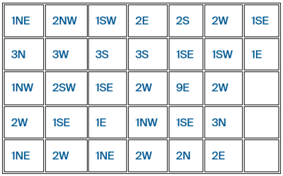
Compass Trefoil Drawing (Source)
You will need a piece of graph paper, at least 13 squares wide and 12 squares long. Start 2 squares in from the right hand side and 3 squares up from the bottom. Trace a line starting from this point, using the following directions (read down the columns):
-
Reading Topographical Maps
Topographic lines on a map are used to show elevation, meaning height above sea level. When more lines appear closer together, this represents higher elevation at a steeper grade. If possible, have a topographical map of the local area for girls to see before the activity. Can they spot any hills they regularly see?
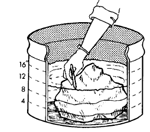 For this activity you will need a dark marker, light-colored round container, large irregular-shaped rock, water, siphon or large syringe and a grease or wax pencil.
Using the dark marker, draw lines on the outside of the container parallel to the rim at one-inch intervals. View the container from above. Note how the lines form concentric circles that look much like contour lines, which appear on maps to join points of equal elevation.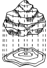
To further illustrate the concept, fill the container with water and place the large irregular-shaped rock inside so it is completely covered. Using the siphon or syringe, remove water from the container until one inch of the rock is exposed. Use your grease or wax pencil to mark a line around the rock at water level. Repeat the procedure until the rock is completely exposed. View the rock from above and notice the grade of elevation.
-
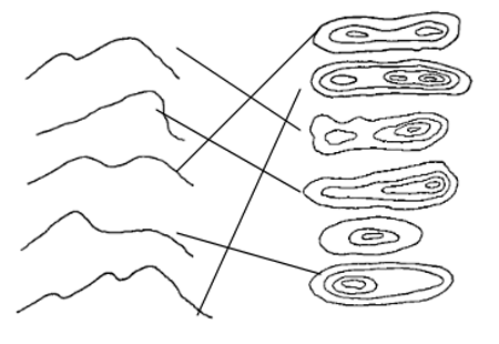
Matching Mountains
When you look at a topographic map, can you visualize what the features look like in real life? Have the girls look at the following mountain ranges on the left and try to match them with the topographical representations on the right.
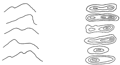
Answers: